
Benjamin Franklin Surveys the Post Road Here
- Jim Lampos
- Jun 2
- 11 min read
It was late January 1755 when Benjamin Franklin crossed the Rhode Island border into Connecticut to survey New England’s Lower Post Road. The weather was unusually warm, as were his thoughts for a certain young woman he met in Boston, one Miss Catharine Ray whom he called “my Katy.”

Franklin had been appointed Joint Deputy Postmaster for the colonies in August 1753, and in September 1754 was to survey the “lower post road” with his co-deputy postmaster William Hunter. The plan was to inspect existing post offices, establish new ones, measure the road accurately, and be home before winter. Things did not go according to plan. Hunter became gravely ill postponing the survey.
A new plan took hold after Franklin met the lovely Catharine Ray. Katy travelled the first leg of the survey trip with Franklin, parting ways in Westerly where she set sail for Block Island to care for an ailing parent. From there in January 1755, Franklin crossed into Connecticut alone. But Franklin’s thoughts continued to roam to his Katy, and he wrote to her in early March once he arrived at his Philadelphia home:
“I left New England slowly, and with great Reluctance: Short Days Journeys, and loitering Visits on the Road, for three or four Weeks, manifested my Unwillingness to quit a Country in which I drew my first Breath, spent my earliest and most pleasant Days. I almost forgot I had a Home...”
Franklin’s letters to Katy give us some insight into his travel along the Connecticut shoreline carrying out his duties as the colonies’ Deputy Postmaster.
It is worth remembering who Franklin was at this moment. He was not merely a postal official making his rounds. By 1755 he was arguably the most famous man in America, and certainly the most famous American abroad — the editor of Poor Richard’s Almanac, the man who had demonstrated electricity with his kite experiment just two years earlier, and whose lightning rods now stood atop buildings across New England. Franklin was on his way to becoming a legend. True to form, this didn’t stop him from carrying out his official work for the postal service, but he was going to enjoy the ride. This goes some way toward explaining the stories that have attached themselves to his passage through Old Lyme.
Franklin in Old Lyme: Legend and Fact
The best-known Old Lyme tale holds that as Franklin rolled through town a little girl rushed out to greet him offering a piece of johnnycake, which Franklin declared “the best he ever had.” Legend has it that the stretch of road was renamed “Johnnycake Hill” in honor of the fortuitous meeting. For a long time, this was dismissed as a charming local myth. But the circumstances of Franklin’s newfound fame and his leisurely pace in executing his postal duties lends plausibility to the tale. A second legend, that he discovered a wellspring of fresh water at the confluence of what is today Four Mile River Road and Shore Road, a spot known until recently as “The Well-Sweep,” is equally plausible, as he had given himself ample time to muse and make discoveries.
What is not legend but firmly established fact is the purpose and result of Franklin’s survey. Franklin travelled with a proto-odometer (or “wayweiser”) of his own making: A device attached to the axis of a carriage wheel that counted rotations and calculated distance. The device allowed him to accurately survey and have miles marked along the post road, thus helping rationalize the postal service. Reverend Ezra Stiles, a careful diarist, leading intellectual, and close friend of Franklin’s, journaled:
“Benjamin Franklin by a Machine fixed to Axis of Chain Wheel in 1755 measured 14 ¾ miles from New London Ferry to Saybrook.”
A stone marking the 14th mile from New London as measured by Franklin still stands on Johnnycake Hill Road and is known as our “Franklin Milestone.”
Franklin’s mile markers allowed for his directives as postmaster to be carried out efficiently, as when he set a table of fees and requirements for post riders in 1763. This is not to say that Franklin set the milestones himself, but it would seem certain that the location of the mile mark would have been noted at the time of his survey.
A note on the Old Lyme milestones: There are several markers in Old Lyme sometimes called “Franklin Milestones” — including one on Ferry Road and another by the North Green on the Boston Post Road. These brownstone markers are not from Franklin’s era. They date to the early 1800s, when Moses Warren surveyed a new route for the Post Road along the Lyme and New London Turnpike, which follows today’s Lyme Street and Route 1 north of town. A reproduction milestone in front of Center School on Lyme Street would have been based on the Warren turnpike survey. Only the stone on Johnnycake Hill Road is genuinely Franklin’s.
Down the Old Post Road
With that background in hand, let’s trace the Lyme route Benjamin Franklin would have first surveyed in the early days of 1755, and take in some sights that he would have seen at that time which we can still see today. Our route will essentially follow Route 156 through Niantic into Old Lyme, turn right onto Mile Creek Road, then another right on Johnnycake Hill Road (or Ben Franklin Road, as we shall see), follow Johnnycake Hill down to McCurdy Road toward town, then around the bend at the Town Green and taking a left on Ferry Road, and following that all the way down to the Connecticut River.
Amazingly, a good portion of this journey would be recognizable to Franklin were he to take the same route today.
1. The Niantic River Crossing

Franklin entered “Lyme,” which then included East Lyme, by crossing the Niantic River at the Rope Ferry. A barge or scow tethered to ropes spanning the river, hence the name “rope ferry," made for a relatively stable crossing of that turbulent channel. If Franklin were to return today, he would recognize the swirling channel -- if not the latest version of the bridges that replaced the rope ferry at the end of the 18th century.
2. The Nehantic Burial Ground — McCook Park
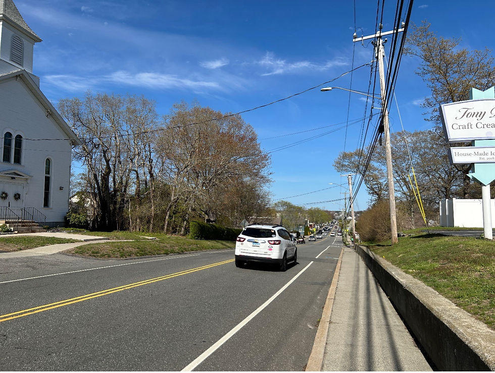
Passing through what is now downtown Niantic, Franklin would have traversed the land of the indigenous Nehantic peoples, whose settlements Reverend Ezra Stiles denotes on his map of our region as “wigwams on the shore.” At the crest of the hill as we leave downtown Niantic, today we find McCook Park just south of Route 156, which in Franklin’s time was the Nehantic reservation and their tribal burying ground. Neither the church nor obviously the ice cream shop in this photo were there in Franklin’s day; but the ridge itself was well noted and a small portion of the once vast Nehantic burial ground is preserved in today’s McCook Park.
3. The Thomas Lee House

As we approach today’s Rocky Neck State Park, we come to an area that was known as Little Boston. On our left is a home that Franklin would have seen. The Thomas Lee house, built in 1660, still stands and is a beautifully preserved structure from the earliest period of English colonial settlement.
4. The Griswold Milestone

Keep a sharp eye out for a stone across the street from the Lee House: in front of the motel is a milestone indicating to travelers that it was 9 (“IX”) miles to New London and also announced the colonial home of Revolutionary War veteran Andrew Griswold. Griswold’s home, “Bride Brook Manor,” which at various points served as an inn and tavern, was a local landmark through the 20th century but was torn down sometime around 1967. The stone miraculously remains.
5. The Chadwick House at Four Mile and Shore Road

As we enter Old Lyme, we take the familiar bend coming from Niantic and the Chadwick house is on our right at the corner of Four Mile River Road and Shore Road. Birthplace of Captain Daniel Chadwick, this lovely example of gambrel architecture was built around 1720.
6. The Fork at South Lyme Chapel

As we proceed west on today’s Route 156, we come to a fork in the road-- Shore Road continuing to our left and Mile Creek Road veering to our right, with the lovely South Lyme Chapel marking the intersection. The chapel was not here in Franklin’s day; but today it not only provides a place of spiritual respite but also a point where Franklin’s post road diverges from today’s Route 156, which we have been following since the Niantic River. In 1755, the post road followed Mile Creek Road and wound its way through ridges and recessional moraines, fording the Three Mile River, Armstrong Brook, Swan Brook and the Black Hall River at relatively easy crossings.
7. The Colonial Homes of Mile Creek Road

Along Mile Creek Road we see an extraordinary collection of colonial era homes in the classic Cape, gambrel, and saltbox styles, many of which Franklin would have also seen on his journey. The most dramatic is another Chadwick house, this one built in 1690 on a prominent knoll, and one of several 17th century homes that survive in Old Lyme.
8. Johnnycake Hill Road and the Greenfield House

After crossing the Black Hall River, we will take a right off today’s Mile Creek Road and go up Johnnycake Hill Road. When Franklin arrived in 1755, the Post Road continued up Johnnycake Hill Road to the old Meeting House on top of the hill. Along the way, Franklin would have seen this home, the Greenfield house, built around 1690 which can still be seen on Johnnycake Hill Road just before the railroad tracks.
9. Ben Franklin Road

Perhaps it was while enjoying his snack of johnnycake when the idea struck Franklin that going up what is now called Johnnycake Hill Road was taking the long way around. Instead, he favored a shortcut that went straight up the hill at a steeper incline—and caused to be cut a new path that would later be named for him: Ben Franklin Road.
If we double back from Johnnycake Hill Road to Mile Creek Road, retrace our steps and instead follow Ben Franklin Road up the hill from Mile Creek, we come to an unpaved portion that is now a private property that requires permission to access. This unpaved portion of Ben Franklin Road is perhaps the best-preserved portion of the post road from Franklin’s era. While the land would have been mostly cleared of trees in Franklin’s day, the landscape remains essentially unchanged and the wheel ruts from the conveyances that traversed the well-traveled post road are still visible today.
10. The Old Meeting House Site
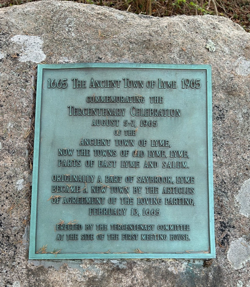
With railroad intersections and private property changing the modern journey, we should travel Shore and McCurdy roads to skirt our way around to the top of the west side of Johnnycake Hill Road, where the unpaved portion of Ben Franklin Road rejoins Johnnycake Hill Road. This is near the site of the old meeting house, marked by this plaque and the Meeting House Hill cemetery. We can now continue Franklin’s journey making our way down the hill toward the center of town.
11. The Franklin Milestone

Near the bottom of Johnnycake Hill stands the “Franklin Milestone” marking the 14th mile from New London as measured by Franklin.
12. The Duck River Cemetery

At the bottom of the hill, we cross the Duck River and come to the cemetery named after it, which at the time Franklin would have seen it already had three generations of townspeople taking their eternal rest beneath beautifully carved slates, granites, and brownstones.
If he went in to pay his respects, Franklin would have seen the graves of Old Lyme’s founders, including Reynold Marvin who sat on the town’s first Board of Selectmen in 1667.
13. The McCurdy House and the Town Green

Just up ahead, the Post Road bent around the home of John McCurdy, seen here on the right, just as McCurdy Road does today as it becomes Lyme Street. Franklin would have seen the McCurdy home, the original portions of which were built circa 1700. McCurdy at the time was on his way to becoming one of Connecticut’s richest merchants and most dedicated revolutionaries. This view is taken from the Town Green (today referred to as the “South Green”). A descendant of the famous Charter Oak was planted in April 2026 by the Old Lyme Tree Commission and is pictured in the center. The Town Green was the epicenter of revolution in Old Lyme. In a few short years after Franklin’s visit, an effigy of tax collector Jared Ingersoll was hung here in protest of the Stamp Act in 1766; a bonfire was set of a rogue peddler’s tea in Lyme’s own version of the Tea Party in 1774; George Washington spent an evening at McCurdy’s home in 1776; General Lafayette quartered his troops on the green in 1778; and, also stayed with McCurdy. The French “hero of two worlds” returned again in 1824 on his grand tour of the new nation as it approached its 50th anniversary of independence and had breakfast at the McCurdy house.
14. The Parsons Tavern Site

The lovely Congregational Church across the street from McCurdy’s home was not there in Franklin’s time, but the home next door to the church (known as the Ludington Mansion) was then the site of the Parson’s Tavern where Jonathan Parsons, the New Light minister of the First Society’s congregation had once lived and raised his family with his wife Phebe Griswold Parsons. While Reverend Parsons had relocated to Newburyport by the time of Franklin’s visit in 1755, his sons Marshfield Parsons and Samuel Holden Parsons remained in Lyme with Marshfield turning the family home into a tavern. Samuel studied law under his uncle Matthew Griswold IV, and became King’s Attorney for New London county. He also became a dedicated patriot during the days of the Stamp Act rebellion, and during the revolution served as a major general in the Continental Army and was a close advisor to George Washington. Franklin’s Post Road followed Ferry Road at the intersection of today’s Lyme Street, and a memorial stone for Samuel Holden Parsons can be found on Ferry Road in front of Lyme Regis, on the left just past the church.
15. The Lieutenant River and the Turnpike Milestone

Follow Ferry Road and take a right onto Shore Road. Cross the Lieutenant River at what was called “The Great Bridge” in Franklin’s day, then take your first left to continue on Ferry Road toward the Connecticut River. On your right you’ll come to a stone marking the 15th mile from New London. However, this one is not from Franklin’s era, but rather from the “turnpike” era in the early 19th century.
16. The Connecticut River Ferry
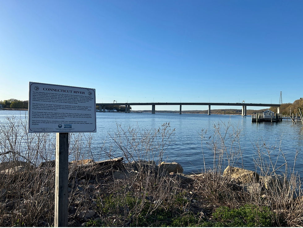
At the bottom of Ferry Road, we finally come to the approximate site where Franklin would have boarded a ferry to cross the broad Connecticut River to Saybrook. No bridge spanned the lower Connecticut River in Franklin’s day, but he certainly would recognize the broad and mighty Connecticut were he to see it today. Franklin then made his way to New Haven where Reverend Ezra Stiles would honor him with an oration at Yale College on February 5th “for His Outstanding Calculations and Remarkable Discoveries in Electricity.”
Post Road Revisited: October 1763
Deputy Postmaster Franklin made one more official trip to inspect the Post Road during 1763. Franklin felt confident enough in conditions on the road to have his 19-year-old daughter Sally accompany him on the New England leg of the trip, he driving the carriage and she riding the saddle horse alongside him on the route he had surveyed and improved eight years earlier. It was during this trip that Franklin wrote down the only itinerary we have of any of his journeys as Deputy Postmaster, included in a letter he wrote to his sister Jane (Franklin) Mecom on November 7, 1763. From the letter we learn that he arrived in New London on Saturday, October 22nd, staying among friends there until Tuesday the 25th, and reached New Haven on the 27th. He does not say where he spent the night of the 26th, but the timing places him in Old Lyme on or around October 25th -- traveling the same road he had measured and improved nearly a decade before.

Franklin’s 1763 inspection of the Post Road provided the basis for “Tables of the Port of All Single Letters” that was published by B. Franklin and J. Foxcroft in 1765 for use by postmasters and the general public. Franklin made explicit mention of charging “one Penny Weight of Silver for every mile” for Expresses “sent along the Post Road” or “from any stage to anyplace.” Taken together with his other instructions and references, it appears certain that Franklin’s 1755 work accurately measuring and surveying the road had been codified and marked well in advance of his return in 1763.
Franklin’s influence on us reaches far beyond the postal service, from his scientific discoveries to his role in shaping the philosophy of American self-government. But there is a more familiar legacy he left here in Old Lyme including a road still bearing his name and a milestone still counting his miles. Were he to retrace his journey on the Lower Post Road today, he would not only readily recognize the landmarks of our town and the loveliness of its aspect, but he would celebrate the persistence of our democracy and the vibrancy of our town meeting. He would equally celebrate our industriousness and leisure, our studiousness and our pleasures. And as in a letter to his Katy referring to being beloved, he may even find Old Lyme “pleasing to [his] Humour.” And may it be so 250 years hence.


Comments